This week’s activity is to show children how it is that the world is round, but maps are flat. Children may watch, and then actively participate and explore these ideas. Before this lesson, I like to be sure the child has had plenty of experience with the Land, Air, Water materials. The adult can speak in the lesson, or chose to show this silently, depending on your age group and crowd. I wrote what I sometimes say below in italic.
Needed for lesson:
- Globe, sandpaper or traditional
- World map
- Earth toned clay or play dough
- A safe knife
- Curious child(ren)
If the world is round, why are maps flat? Let me show you.
People need maps to navigate throughout the world, to visit friends, to go on long distance adventures, and to discover new areas. Since we can’t carry around a globe large enough to show the tiny details people need to travel, we use maps.
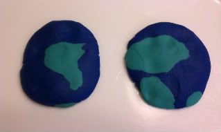
After constructing a model of Earth with dough, cut it clear in half. Show the children the two sides. Place them on a tray, flat side down, and push down on them with your palm until they are flat. Both hemispheres are represented. The picture below was made, cut, and squished by my four year old!
A long time ago, people took a model of the Earth and cut it in half and flattened it. From that, they drew maps. Maps are pictures of land and water they way it looks from the air.
At this point, I like to point out on a Montessori World Map that there aren’t two earths, just that it has been cut in half to be made flat. With older children, I mention that there is only one Antarctica and one Asia, both continents have been cut for the map to show both sides of the earth at once.
Next Monday, join us for a lesson in Map Drawing for kids!
Jessie is a Primary Montessori Teacher and Mom to twin three year olds and a four year old. Jessie has a Montessori blog at The Education Of Ours, and can be found on Twitter.
pink and green mama
Sunday 3rd of July 2011
Adorable! Thanks for linking up and sharing this with the Smart Summer Challenge!
Fondly, pink and green mama MaryLea
Practical Parenting
Thursday 30th of June 2011
This is fantastic! Trying it out tomorrow!
Montessori Print Shop
Tuesday 28th of June 2011
What a fantastic way to visually explain this! We'll definitely add a link to this post in our Geography section as it's always a bit of a stumbling block for new teachers. Thank you Jessie!
Alina
Monday 27th of June 2011
This is an awesome illustration!!!! Thank you for sharing!
Multi-Testing Mommy
Monday 27th of June 2011
Very cute lesson - I was a Kindergarten teacher prior to having my own kiddos - LOVE it!
I'm here saying hi from the Canadian Blog Hop although I was already a follower ;)